8.2. METAR
METAR, which stands for Meteorological Terminal Air Report, is a standard report that provides meteorological information specific to an aerodrome. It can also be referred to simply as a routine aerodrome meteorological report.
8.2.1 What is Included in a METAR
The METAR report follows a prescribed format and includes various elements, typically presented in a specific order as listed below:
- Location (ICAO for the Airport)
- Date and Time of the METAR report
- Surface winds
- Visibility
- Weather
- Clouds
- Temperature and Dewpoint
- Altimeter Pressure
- Trend
8.2.1.1 Location (ICAO for the Airport)
The ICAO indicator of the reporting station. For example, OEJN.
8.2.1.2 Date and Time of the METAR report
The day of the month and the time of the observation in hours and minutes in UTC/ Zulu
| 231000Z | The METAR was recorded on the 23rd of the current month, at 10:00 Zulu. |
|---|---|
| 191330Z | The METAR was recorded on the 19th of the current month, at 13:30 Zulu. |
8.2.1.3 Surface winds
| 36010KT | Wind 360 degrees at 10 knots |
|---|---|
| VRB05KT | Wind variable at 5 knots |
| 00000KT | Wind calm. |
| 25018G30KT | Wind 250 degrees at 18 knots gusting to a maximum of 30 knots. |
8.2.1.4 Visibility
| 0500 | Visibility is up to 500 meters. |
|---|---|
| 7000 | Visibility is up to 7000 meters (or 7 Km). |
| 9999 | Visibility is up to 10,000 meters or more (10 km or more). |
| 8888 | Visibility is up to 8000 meters or more (8 km or more). |
| 0000 | Visibility is less than 50 meters. |
8.2.1.5 Weather
Weather is indicated by up to 3 groups comprising symbols and letters from the following:
| + | Heavy | DZ | Drizzle | IC | Ice Crystals | SN | Snow |
|---|---|---|---|---|---|---|---|
| - | Slight | FG | Fog | MI | Shallow | SQ | Squall |
| BC | Patches | FC | Funnel Cloud | PL | Ice Pellets | SS | Sandstorm |
| BL | Blowing | FU | Smoke | PO | Dust Devils | TS | Thunderstorm |
| BR | Mist | FZ | Freezing | RA | Rain | VA | Volcanic |
| DR | Low Drifting | GR | Hail | SA | Sand | VC | In the vicinity |
| DS | Dust Storm | GS | Small Hail | SG | Snow Grains | UP | Unidentified Precipitation |
| DU | Widespread Dust | HZ | Haze | SH | Shower | RE | Recent |
Examples of compromising symbols
| +SN | Heavy Snow. |
|---|---|
| SHRASN | Shower Rain and Snow. |
- Clouds Cloud amount is reported by specific symbols followed by the height of the cloud in hundreds of feet.
These symbols are:
- SKC (Sky Clear) = 0/8
- FEW (Few) = 1-2/8
- SCT (Scattered) = 3-4/8
- BKN (Broken) = 5-7/8
- OVC (Overcasted) = 8/8
Examples of a full cloud report
FEW015 = few clouds at 1500ft, SCT030 = Scattered cloud at 3000ft
Other symbols
| CB or TCU | Significant convective cloud |
|---|---|
| VV+ vertical visibility | When the sky is obscured, Vertical Visibility can be shown by VV[Visibility] |
| NSC | No Significant Cloud |
8.2.1.6 CAVOK
When certain conditions occur simultaneously, the term CAVOK (cloud and visibility OK) is used to replace the Visibility, Cloud, and Weather groups in a METAR report.
These conditions are as follows:
- Visibility is 10 kilometers or more.
- There are no Cumulonimbus (CB) or Towering Cumulus (TCU) clouds present.
- There are no clouds below 5000 feet above ground level or the Minimum Sector Altitude (MSA), whichever is higher.
- There is no significant weather affecting the aerodrome or its vicinity.
When these conditions are met, the CAVOK indicator signifies that visibility, cloud cover, and weather conditions are favorable for flight operations.
8.2.1.7 Temperature and Dewpoint
The air temperature and dewpoint in a METAR report are provided in whole degrees Celsius. For instance, a notation such as 25/05 indicates that the air temperature is 25°C and the dewpoint is 5°C. In some cases, the letter "M" may precede the temperature or dewpoint value, indicating a negative or minus value.
For example, M05 would represent a temperature or dewpoint of -5°C. This notation is used to indicate temperatures below freezing or in the negative range.
8.2.1.8 Altimeter Pressure
Aircraft pressure altimeters are instruments that display the aircraft's elevation relative to a specific reference point. The choice of reference point depends on the barometric pressure set on the altimeter sub-scale. The standard unit of measurement for barometric pressure is the hectopascal (hPa).
There are three sub-scales on the altimeter:
-
QNH: This is the pressure set on the altimeter sub-scale to indicate the aircraft's height above sea level.
-
QFE: This is the pressure set on the altimeter sub-scale to indicate the aircraft's height above a designated reference elevation.
-
Standard Pressure: This is the standard pressure of 1013.2 hPa, which is used by aircraft operating above the transition level. It is used to determine pressure altitude (also known as Flight Level) and provides a common reference for vertical measurements.
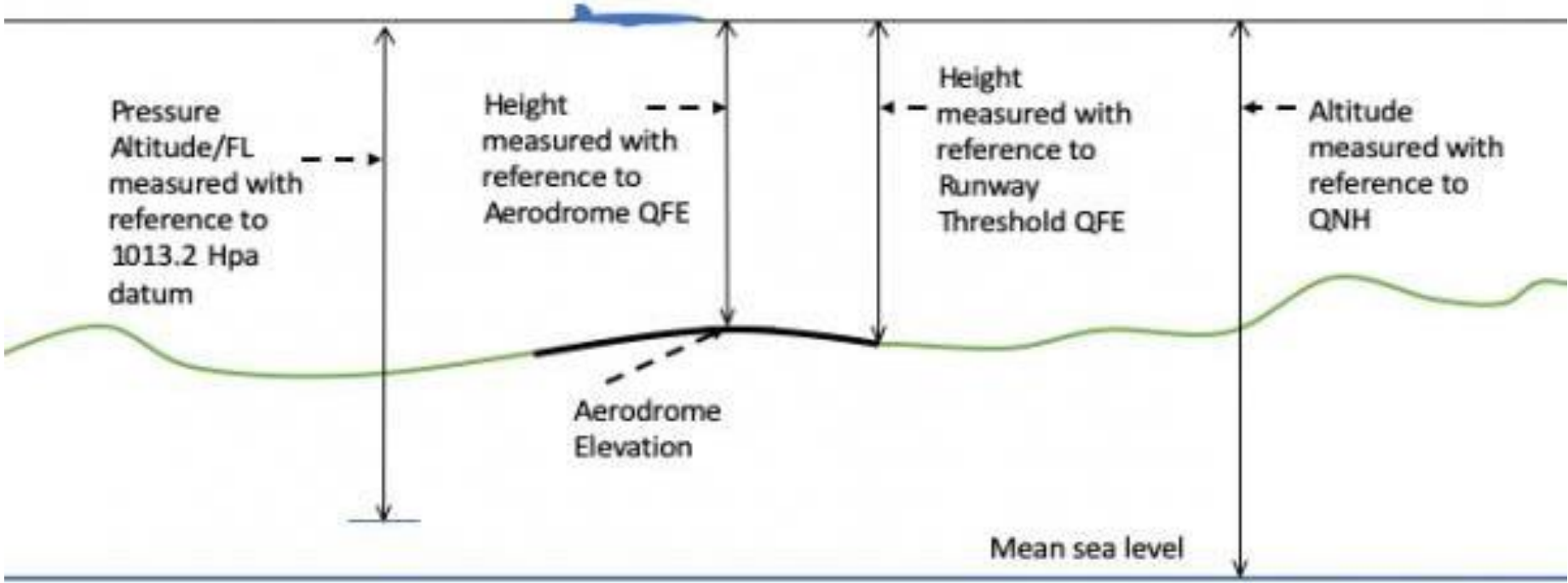
These altimeter sub-scales enable pilots to accurately determine their aircraft's altitude relative to the chosen reference point.
If the QNH is less than 1000, controllers need to mention the unit, hectopascal (hPa).
8.2.1.9 Trend
Trend forecasts are indicated by BECMG (Becoming) or TEMPO (temporary) which may be followed by a time group (hours and minutes UTC/Zulu) preceded by one of the letters indicated FM (from), TL (until), AT (at). For example, BECMG FM1030 TL1130.
NOSIG replaces the trend group when no significant changes are forecast to occur during the 2-hour forecast period.
8.2.1.10 Examples of METARs
| OBBI 162300Z 26006KT 230V290 CAVOK 15/02 Q1022 NOSIG |
|---|
| Bahrain METAR was recorded on the 16th of the current month at 2300 Zulu. Surface wind 260 degrees, varying between 230 and 290 degrees, at 6 knots. Cloud and visibility OK. Temperature 15°C and dewpoint 2°C. QNH 1022. No significant changes. |
| OKKK 162300Z 28004KT CAVOK 05/M09 Q1024 NOSIG |
|---|
| Kuwait METAR was recorded on the 16th of the current month at 2300 Zulu. Surface wind 280 degrees, at 4 knots. Cloud and visibility OK. Temperature 5°C and dewpoint -9°C. QNH 1024. No significant changes. |